What is the South Belt?
Today we understand the South Belt-Ellington Area or simply the South Belt, as an area in/around beltway 8, and I-45 South. According to Marie Flickinger (owner/editor The South Belt-Ellington Leader), the geographic name of the South Belt was on city planners lips since the mid 50s, when plans for the city’s second loop was being considered. Much like western sections of the beltway, was considered the West Belt, and northern sections was considered the North Belt, the South Belt existed as the southern portion of the beltway system. Later, when the first few subdivisions were being built, plans for a local newspaper was being put into place. As those plans became reality, the name of the paper was selected to clearly identify the area it served. While the later part of the name eventually changed, the first part was always the same, the South Belt. The name stuck and over time, has become a ubiquitous label for this area.
The South Belt exists in predominantly three zip codes (77034, 77075, 77089), with a population of more than 138,000. The South Belt is largely comprised of the former Houston super neighborhood No. 80. However, the South Belt extends beyond the city limits of Houston and so also includes some of southern most areas of unincorporated Harris County, as well as portions of east Pearland, and north Friendswood, that logically make up the area.
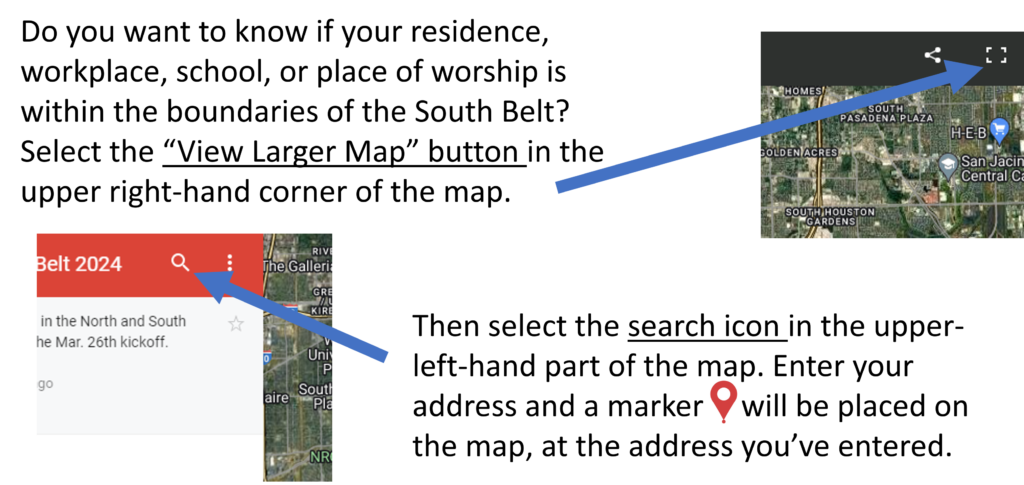
This map is the revised version based on feedback from the members of the Partnership on Mar. 26th, 2024.